Earthquakes and tsunamis are rocking planet-earth while concerns are being expressed of warnings made by environmentalists that global warming could melt ice caps in the Himalayan range. The question arises therefore as to how far the shape and size of Sri Lanka had been subjected to ravages of natural disasters down the ages and how long had she maintained her teardrop figure?
Scientific research has revealed that Sri Lanka had been part of the landmass of the Indian subcontinent several times in the last millennium and that she had commenced her current spell as an island around 7000 years ago. However, it is interesting to examine whether Sri Lanka maintained her shape and size even after she was formed into an island.
According to the first map available of Sri Lanka drawn based on calculations and descriptions given in “Geographia” authored by Ptolemy (Claudius Ptolemy) in 150 AD, Sri Lanka, identified as Taprobana, was an island positioned close to the tip of the western coast of Southern India.
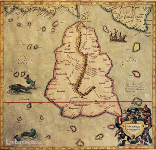 |
| Ptolemy’s map of Sri Lanka |
“Geographia” was translated from Greek to Arabic in the ninth century and later to Latin in the fifteenth century when the manuscript was rediscovered and European cartographers reconstructed the world map accordingly. On this, Lady Lanka had been much more plump – broader at the base with a bigger landmass at the top. The land area in the oversized and triangular shaped island had been ten times bigger than its present size, which is attributed to inaccurate information given by maritime travellers at the time. Ptolemy who had not visited Sri Lanka, had drawn information for his “Geographia” from merchants and navigators during his sojourns in the sea. He named the island Taprobana as she was identified at the time by the Greeks and called Sri Lanka “Salika,” its people “Salai.” Taprobana incidentally had been mentioned as one of the major geographical locations in Ptolemy’s “Geographia” along with Europe, Arabia, India, the Malay peninsula and China (Sinae.)
Although the shape and size of Ptolemy’s map differs from the Sri Lankan map of today, most of the geographic positions marked such as the main central hills and the rivers are fairly accurate. The city of Anuradhapura (given as Anurogrammi) appears more towards the Northwest while names of Nagadiba and Galiba have been marked in the North. Nagadiba – today an island, was marked on the mainland along with Galiba. At the time Ptolemy wrote “Geographia,” King Bhatikatissa was reigning in Anuradhapura (134-164 AD) and South Indian invaders had not yet occupied the Jaffna peninsula. Therefore, Tamil names of places had not made an appearance on this map. Also, the present cluster of islands and the Jaffna peninsula appear to have been one landmass and the lagoon between the mainland and the peninsula had still been there.
Analysts say that Talakory and Moudouttou marked on the map may be Talaimannar and Matota. These markings illustrate that there had existed a working knowledge of Sri Lanka’s topography among European traders and mariners which explain as to how cities, trading centres and ports - places particularly important to seafaring traders had found its way to the map.
However, besides geographical markings, are the size and the shape as given in Ptolemy’s map exaggerated?
Sri Lanka had been historically documented long before Ptolemy by navigators. Onesicritus, the Greek navigator in Alexander’s army it is argued, may not have sailed from India to Sri Lanka around 330 BC, if he did not possess knowledge of the topography of the country.
And in 44 BC, the information on the position and the extent of Sri Lanka given by Diodorous Siculus had also been similar. During the diplomatic exchange of visits between Sri Lanka and Rome, the size and richness, the urbanized cities and the fairly dense population had come into focus and the early Greek and Roman visitors to Sri Lanka had been aware that Sri Lanka was far greater in size.
Besides, with sea travel opening new worlds, Sri Lanka on the crossroads of the ancient sealanes was familiar ground to mariners, traders and explorers. Hence topography of Sri Lanka may have been common knowledge among them.
Therefore, how far can we accept the fact that Ptolemy’s map was inaccurate?
The 13th century explorer Marco Polo quoting navigators who had been repeating what had come down by word of mouth had this to say in his travel tales: The island of Ceylon is the best island of its size in the world. You must know that it has a compass of two thousand and four hundred miles but in old times, it was greater still, for then it had a circuit of about three thousand and six hundred miles as you will find it in the charts of mariners of those seas. But the north wind there blows with such strength that it had caused the sea to submerge a large part of the island and that is the reason why it is not so big now as it used to be. For you must know that, on the side where the north wind strikes, the island is very low and flat in so much that in approaching from board ships from the high seas, you do not see the land till you are right upon it.”
While Marco Polo’s records endorse Ptolemy’s dimensions of Sri Lanka he says that the forceful Northeast monsoons were responsible for the submerging of a large part of the landmass in the Northeast. In the meantime, Mahavamsa speaks of the sea flowing inland in the Kelaniya Kingdom – an episode which speaks of an event akin to tsunami.
However, apart from natural disasters, coastal erosion and geological factors that may have contributed to change Sri Lanka’s contours, according to Professor Siran Deraniyagala, the former Director-General of Archaeology, it was the rise and fall of the sea level which occurred due to cold/warm fluctuations that determined Sri Lanka to be part of the Indian subcontinent or as an island. The size of Sri Lanka too may have changed according to variations of the sea level.
The sea level according to research may have dropped at least on seventeen occasions in the last 7,00,000 years resulting in the creation of a landbridge between Sri Lanka and the subcontinent. The last separation Professor Deraniyagala says may have occurred about 7000 years ago.
Therefore, when humans were known to have existed in various parts of India in the last one million years, Sri Lanka had been connected to the subcontinent on numerous occasions. It is very likely therefore, that the first settlers from India reached Sri Lanka at least as early as one million years ago, perhaps even earlier. Excavations conducted in coastal deposits near Bundala reveal that there had existed prehistoric settlements in Sri Lanka about 125,000 years ago. Tools of quartz and a few on chert discovered from the area, date back to this era.
Professor Deraniyagala states that the earliest settlers who made their home in Sri Lanka, may have walked across the landbridge when the two countries were one landmass. Therefore, while Sri Lanka’s contours have been transient and her maps seasonal, scientific research reveals that the launch of the Sri Lankan nation and its historical developments had been fashioned on the lines of the formation of the country which had taken shape according to climatic developments. |

