With the experience gained on our many expeditions starting with Bible Rock, we thought we should go in for some real adventure in a countryside yet unknown - the Sinharaja rainforest.
We selected the eastern part of Sinharaja entering from Deniyaya and trekking through the wilderness with the hope of coming out in three days at Pothupitiya on the other side of the sanctuary. We planned to find our way with the aid of a one inch map and a compass.
We took the long tiresome journey to Deniyaya, after a late lunch at the home of a fellow hiker and checked into the good old Deniyaya rest house.
As we came out to the verandah the following morning, we were treated to a breathtaking view of a vast range of cloud-clad mountains stretching across a mist covered valley. This was the Rakwana range extending to the west from Sooriyakande, the tallest mount at the east end, with the Sinharaja forest below.
We settled on a route. Leading out from the last motorable point, a village called Kiriweldola we would trek north, up an incline, till we reached a height of 1000 ft. We would be at the foot of the twin peaks Heenpitigala East and West at a height of 1600 ft.
 |
 |
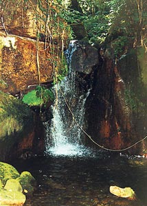
| Waterfall seen on descent from Henpitigala |
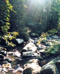
Silent forest: A typical morning in Sinharaja |
We would then have to deviate from the north direction to bypass the peaks, to reach the summit of the range and then go down to the valley to the Delgoda Oya, a tributary of the Kalu Ganga. Pothupitiya was beyond this stream.
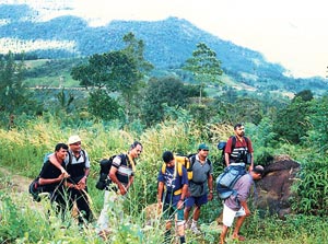
The route seemed to have in it everything we wanted, rugged terrain and an unknown route over the entire breadth of Sinharaja. After a heavy breakfast we set out with enough dry rations in our backpacks, Having reached the last motorable point by vehicle, we started walking up a gravel road.
After crossing a stream identified as Ging Ganga we reached the Kiriweldola hamlet. Totally unknown to us, we had been all the while stalked by two young men, one of whom had been a Special Forces deserter.
The two volunteered to take us to a place called Brahmana Ella, inside Sinharaja. We were stupid enough to accept. We were then taken through a strange countryside of paddy fields and tea gardens amidst warm greetings from smiling villagers to finally reach the border of the Sinharaja forest where the people of the last household treated us to a welcome, hot cup of tea.
From the border of the forest we walked along a footpath to reached the Brahmana Falls, stopping on the way only to partake of the lunch packets that we had from the rest house. As we had reached only the top of the waterfall we could not get to see the full falls.
Resuming the trek after lunch we kept walking upstream. Later on as the real ascent got underway, the rocks became bigger and more slippery. If one was not careful on each and every step, one would take a disastrous fall.
Trekking on day one ended at about 4 o’clock. The camp site selected was a small island in the river. One group prepared the ground for the tents while another went in search of firewood needed for cooking and a bonfire.
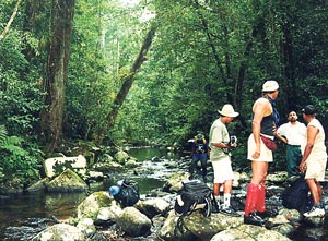 |
| Small rocks jutting out of water forming our stepping stones in the initial part of the way up |
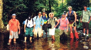 |
| Cooling off: On flat stretch on the second day |
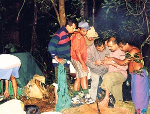 |
| What next? Looking for way out in the map on second night |
 |
| The last lap: Having descended from Sinharaja |
 |
| Last stop: The house of good hope that we saw from above as the earliest evidence of human inhabitation |
Day 2 began with a typical misty morning in Sinharaja with sun rays filtering in through the gaps in the tree canopy. A bird watcher in the group made the best use of these sombre hours of the morning to view some rare species. Some set about making a breakfast of Mung kiribath, and others dismantled the tents.
As we trekked further upstream, the rocks became too tall to climb, so we took to the river bank. Taking the land route though safe, was equally difficult due to the thick undergrowth obstructing our advance.
Even after trekking for hours, the river showed no sign of narrowing as it should on nearing the summit. Instead we came out to a flat stretch. We were now in despair with the summit we were heading for, seemingly nowhere near.
The scenery that opened up with the river flattening out into pools was however breathtaking. The water bordered by tall trees, had a gloomy appearance because of the thick canopy interspersed here and there by rays of sunshine. Walking through these pools was easy as there were no rocks at the bottom even though the water was thigh deep at places.
The sight of multiple tributaries resembling a network of man-made irrigation channels itself was unique. It gave the appearance of a network of roads and was as confusing, as to which the main waterway that we had been following was.
With the aid of the compass we continued to keep moving in the northern direction. Proceeding for some distance, we found that it was taking a curve to the east and that the map showed that following this tributary we would land at the feet of the twin peaks. We had three options here.
One was to head straight north in which case we would be climbing the peaks and going down straight to Poththupitiya -the shortest route. The other options would be to go round the mountains thus heading either north east or north west, both of which would have been too long. It was imperative that we should, before nightfall, cross the summit of the range and also go down a fair distance till we would get water to camp out. We decided that we should leave the river and head straight north.
This move later on came in for much criticism as the route became hopelessly steep. We had to literally crawl by hanging on to branches of trees whilst leeches were sucking our blood in bunches all the while.
We halted at a relatively open space with a bird’s eye view right round. On to our west was a vast valley extending down to the horizon. To the east was the peak that we were climbing. The only evidence of human habitation was seen to the south east in the form of a tea factory. We decided to deviate slightly to take a northwest course, and climb the peak rather tangentially with a view to bypassing summit of the peak.
Finally we reached the the western slope of the Heenpitigala West Peak. On to our west was once again the vastness of the Sinharaja forest extending down to the horizon. The way straight ahead of us was a valley across which was seen another range of mountains. For a while we were flabbergasted as to how we would cross the valley, climb the mountain range and then go down from there, till we reached water before nightfall as the time was around 3.30 in the afternoon.
But as we went down, springs of water started appearing which merged together to form small streams and still larger ones lower down. When the streams were large enough to collect water for our purposes and the terrain showed some flat area, large enough to erect our tents, we halted for the second night’s rest.
Unlike the carefree and jovial first day’s night the second night was anxiety ridden. The mere thought of the possibility of a third day’s night to be followed by a fourth day’s trekking was frightening. After a hurriedly prepared dinner of rice, dry fish and dhal we retired to our tents.
The following morning some were of the view that we should continue to follow the waterway which was flowing down in a southwesterly direction anticipating it to curve round the mountain range to take a northern course. It was felt that we would, by this way be able to bypass the mountain range. That turned out to be wishful thinking only as there was no such evidence on the map.
The river continued to flow in the same direction. Had we followed this river, we would have trekked for days across the entire vastness of Sinharaja from north east to south west. Some unknown power prevented us from taking this route.
The decision was made finally to cross the mountain range on to the north, by however keeping to a northwest course as we did before thereby avoiding the peak and then heading north directly, once the steep stretch was over. With the able navigation of ex-Air Force Doctor Sunil Silva, within about three to four hours of trekking, the northern skies started opening before us little by little. With the aid of binoculars we were overjoyed to see at a distance, human habitation in the form of a tea estate and the roof of a house.
From then onwards, the long awaited descent to the promised valley commenced. This was going to be the toughest and most dangerous part of the hike. We were to descend a precipitous slope, hanging down from branches of trees or shrubs and at times sliding down on our buttocks. Snakes were very frequently seen here. Luckily our S.F friend could spot the snakes in their most camouflaged hideouts.
We were finally close to bidding goodbye to the forest that kept us spellbound for three days and two nights. We could see the roof of the house and the tea estate. But first we had to get rid of the strong bush odour that we had acquired from the jungle by having a good long plunge in the cool waters of the river
Pothupitiya lying in the valley of Delgoda Oya, a branch of Kalu Ganga looked a prosperous countryside with lush tea gardens and paddy fields side by side, similar to Kiriweldola which was in another river valley that of Ging Ganga. We had thus in our hike, really crossed over from the valley of the Ging Ganga to that of Kalu Ganga.
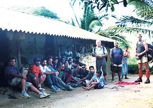
To the people of Pothupitiya, we looked aliens having all of a sudden descended from Sinharaja. Nevertheless they were very happy to receive us.
When we finally reached the road, we could see Sinharaja behind us while across the river far away in the distance was the Rakwana range. In the valley between these two ranges lay the Kalu Ganga.
So behind us was a memorable hike packed with emotion, excitement and adventure.
With the successful completion of this hike we had finally graduated to the state of accomplished hikers.
|

