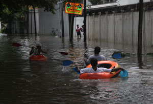
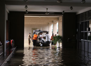
Every year, in some more than others, the city of Colombo and its suburbs grind to a halt. Schools are compelled to close, people are unable to get to work, transport services are disrupted, homes are affected and men, women and children are not only displaced but suffer severe economic losses what with furniture floating and houses being damaged.
 |
| Surath Wickramasinghe. |
Why? The skies have opened up and the rains have come. Heavy rains overnight and floods have overwhelmed Colombo, the showpiece of Sri Lanka.
Year in, year out, those in Colombo grin and bear, grit their teeth and pick up the pieces, soldiering on before the next flood hits them full force. The institutions and organizations responsible for offering an explanation and bringing about solutions, give flimsy excuses until the sun shines again and people who have to get on with the task of survival shove it into the recesses of their minds until reality comes in the form of another heavy shower of rain.
This is what happened once again on November 11, with Colombo being hit by torrential rains.
No new solutions only patchwork is carried out after each flooding episode, points out well-known architect and town planner, Surath Wickramasinghe who is also President of the Chamber of Construction Industry.
Mr. Wickramasinghe sees the construction of expressways and highways as one of the major reasons not only for Colombo but several other districts to become vulnerable to flooding in the past few years.
“The earth banks of the expressways and highways, which prevent the free flow of water promote flooding,” he points out, explaining that several districts have become flood-prone due to the Southern Highway, while the Colombo-Katunayake Expressway being built above the Negombo Lagoon and Muthurajawela has resulted in roads, houses and land to the east towards Minuwangoda going under water.
Citing the flooding of Parliament, Mr. Wickramasinghe attributes it to the elevated road which links Parliament Road and Madiwela Road, leading to the Sri Jayewardenepura Hospital.
Some of the other causes for flooding, according to him, are the arbitrary filling of marshes and canal reservations and illegal constructions.
How is it that “illegal or unauthorized” constructions have got both the electricity and water connections, queries Mr. Wickramasinghe, answering the question himself: “Political patronage.”
 |
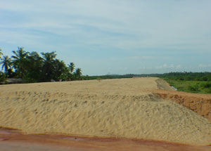 |
| Katunayake Expressway |
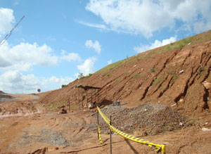 |
| Southern Highway on
the 120 Kahathuduwa bus route |
 |
| The scene inside Parliament on the day of the deluge |
The other reason, he says, particularly in the inner city, boundary walls around large areas such as playing grounds or properties also hinder the free flow of water, leaving two-four feet of water outside whenever it rains. There should be some other way of securing land, he urges.
The inadequate network of drains worsens the situation, says Mr. Wickramasinghe, explaining that in countries like Singapore the drains are wide and deep, and as such easy to clean and maintain.
In the case of this well-known architect he not only points out the shortcomings but also gives the solutions.
Prohibit cheap measures like earth bunds in road constructions in future, he urges, adding that the repercussions of rain havoc due to these come only later, causing much economic losses to the country and suffering to the people. Concrete columns should be used so that filling the land is avoided while increasing the number of culverts, both to allow the free flow of water.
The other action that Mr. Wickramasinghe recommends are the further dredging of low-lying areas to accommodate more flood water and since land is scarce and these areas may be needed for development to allow buildings on columns without filling up the land. “Then both requirements of housing or commercial buildings and flood retention will be met.”
A mechanism should also be introduced, on the advice of irrigation engineers, to harvest the flood water at higher levels without draining almost 80% of it to the sea by opening the flood gates the water to the sea, he says.
The ultimate goal should be to have a planned city and for this nearly 50% of valuable land occupied by under-served settlements should be cleared by relocating these communities in high-rise buildings at suitable locations. Then a new city can be designed.
The time is right now for corrective action to be taken. This can no longer be postponed, stresses Mr. Wickramasinghe.
What the officials say
There are problems in the system such as filling up of marshy lands and unauthorized structures on main drains and culverts which have caused the flood situation, conceded Road Development Authority (RDA) Chairman R.W.R. Premasiri, stressing however that the intense rainfall that day was unusual.
The RDA is clearing blocked water pathways but it will take time to deal with obstructions on private lands as those lands would have to be acquired, he said, explaining that this is a major issue in urban areas. A kilometre stretch will have about 10 culverts, a majority of which will be obstructed.
He has sought assistance from local government bodies as well while the Urban Development Authority is removing illegal constructions on roads and road reservations, he said.
When asked whether highway constructions have contributed to flooding, the Chairman said there may be problems while work is underway. “We get the sizes of openings of bridges and culverts for the highways from the Sri Lanka Land Reclamation and Development Corporation (SLLRDC) and the Central Environmental Authority. But during construction the openings on the pilot roads built to transport construction material may not be of the same size as those of the expressway and may result in temporary problems.”
The flood situation in Kahathuduwa while building the Southern Highway was rectified by implementing SLLRDC recommendations for additional drains, he said, adding that instructions have also been issued to have additional culverts and bridges along the Colombo-Katunayake Expressway.
Questioned as to whether there is coordination among the relevant organizations when road construction plans are drawn up, Mr. Premasiri assured that approval had been sought from stakeholders such as the SLLRDC, the Irrigation Department and hydrologists.
Stressing that the widespread flooding that day had arisen after 19 years, Urban Development Authority (UDA) Director-General Nihal Fernando pointed a finger at unauthorized filling of land and unauthorized constructions as the main cause. The UDA has undertaken relocation of those living on lands unsuitable for building houses.
He refuted charges that the construction of expressways has contributed to the recent flood situation. “National level projects have been undertaken after carrying out suitable studies and cannot have any impact on flood situations,” he said.
Meanwhile, SLLRDC Chairman Harshan De Silva said their main task is to maintain the canal system which has five outfalls directly into the sea and one to the Kelani river. “After land reclamation was taken over by the Defence Ministry, we began by dredging the entire canal network simultaneously since August. About 80% of the work has been done. Earlier dredging was section by section.”
He too echoed the view that unauthorized constructions are the main contributory factors for flooding. There are squatters, the poorest of the poor, occupying reservations and also those who have encroached on water retention areas. “In the Colombo basin there are about 1000 acres for retention but about one third have been encroached on or filled. As a result the city goes under water for high intensity rain,” he said.
“To make matters worse, certain low lying areas such as Lake Drive Road and Royal Park at Rajagiriya have not been filled up to the required level. This is by no means to say filling of land is good. But these lands have not been filled to be higher than the sea level making them more vulnerable,” Mr. De Silva explained.
The Chairman said that when Colombo experienced 440 mm of rain, the water which was flowing out from the outfalls came back due to rough seas.
Going back in floody memory
The lack of adequate water pumping stations to send excess water into the sea and the perennial problem of filling up marshy land are the causes of flooding, said a resident of Kotte who has been dealing with this crucial issue for over 25 years.
Clearly laying the blame for this situation with the past actions of the Land Reforms Commission (LRC) and the SLLRDC, Wesley J. Moses of Jayaweera Mawatha and New Jayaweera Mawatha Welfare Society delves into the 1970s.
The LRC formed in the early 1970's acquired about 50,000 acres of water retaining marshy land in Kotte, Ratmalana, Dehiwela, Kaduwela, Nugegoda, Pagoda, Nawala and Colombo. When the LRC was taken over by the SLLRDC in 1978, the land extent had reduced to about 22,000 acres because the areas had been filled up and built on by the then government, according to time.
Even this vital 22,000 acres which had outfalls to channel excess water during the rains through pumping stations were used for building purposes including the construction of the new Parliament at Sri Jayewardenepura Kotte as well as the roads from there to Rajagiriya and Kaduwela areas, drastically reducing the water retention areas to about 3,000 acres, he said. It was around this time that most of the marshy areas were also filled and sold for private housing schemes like Royal Park and Lake Drive. The SLLRDC office itself was built at Rajagiriya blocking the Hine Oya outfall, he alleged while many a minister of that time built his residence in the area.
The flood destruction began thereafter, says Mr. Moses and in answer the authorities widened the Diyawanna Oya in 1987 while the SLLRDC and the local authority dredged the outfalls and canals.
In desperation, when flood-hit residents led by Mr. Moses appealed to the authorities, the SLLRDC came up with the suggestion that excess water during heavy rains should be diverted from the Kotte area to the Diyawanna Oya, after building a flood bund around the Diyawanna. However, the flood bund was never built due to lack of funds, he said.
Such inaction and careless decision-making resulted in Parliament getting flooded in 1992, when there was a rainfall of 492 mm, he charged, adding that the situation was aggravated more recently by the construction not only of Water's Edge Hotel but also the President's Palace during President Chandrika Kumaratunga's time.
Lamenting that due to such action now not even 1,000 acres are left for water retention, Mr. Moses called for the proper functioning of excess water pumping stations. He pointed out that the pumping station behind Majestic City is not working while the one at Kollupitiya had been demolished to build Liberty Plaza. |

