News
Military boffins now into R&D to meet peacetime situations

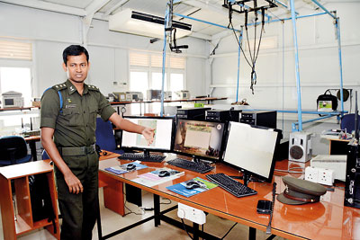
An officer demonstrates how the various simulators work. Pix by Indika Handuwala
In the mid 2000s, the Liberation Tigers of Tamil Eelam started using claymore mines against the Sri Lanka military in earnest. They hid them everywhere, on roadsides, in trees, under vehicles. And they started detonating them via wireless remote control.
The war had started in earnest and the troops found their movements greatly hampered by the use of these mines. Military convoys were particularly vulnerable. The solution was to acquire remote control jammers to block the signals and prevent detonation. But the Government faced difficulty buying enough of them at short notice on the international market.
So, in 2006, the Ministry of Defence set up a Centre for Research and Development (CRD) which it housed at the Panagoda cantonment. A core group of Army personnel was tasked with building jammers. Expertise was gained from the engineering faculties of various universities, primarily the University of Moratuwa. And not only was a jammer made, the CRD enhanced it so that it could detect and detonate a claymore mine planted by the Tigers.
The jammers were subsequently used whenever the Army provided security to VIPs. For a time, they also helped prevent inmates from dialing out from inside the Welikada prison using smuggled mobile phones. This proved problematic, however, as calls outside the range of the jail were also hindered. The CRD is doing research towards developing another solution along with the mobile service provider.
The Centre now has a long list of other technologies and instruments that have been developed in-house. Led by Dr. Thiran De Silva, its Director General and the youngest ever Colonel in the Sri Lanka Army, the CRD aspires to provide them to Government institutions and private sector locally and internationally. But its main objective is to cover at least 50 percent of the country’s defence requirements.
The CRD is made up of five divisions: the Electronic Wing, the Information Technology and Geographic Information Systems Wing, Navy and Air Force Wing. Most of them are now located in a new headquarters building at Panagoda.
Much of the CRD’s early work was modification of the military’s existing equipment to suit evolving needs and situations. For instance, the communication radios that the troops carried to the battlefield had handsets that fell into disrepair and were difficult to replace because spares were simply not available. The CRD swiftly repaired and installed them with switches.
But they soon moved beyond the rudimentary. The IT and GIS Wing had started using satellite imagery in wartime for reconnaissance and to update maps. Later, headed by Lt. Col. Rasika Kahandagamage, it developed a “Global Disaster Risk Analysis, Prevention and Mitigation Application” which won a silver medal at the National Best Quality ICT Awards in 2015.
This system uses aerial photographs and remote sensing (drones) to ensure accurate positioning and security of rescue teams during disasters. It includes a tracking system so that the control room is able to say where troops are. When the Aranayake landslide occurred in May, the CRD officers were the first at the scene. They combined this application with a drone manufactured in-house to provide the first accurate, aerial images of the disaster zone.
They also employed it at the site of the Bulathkohupitiya landslide and in Salawa, where an ammunition dump caught fire. Among other accomplishments, the IT and GIS Wing has provided a massive geo citizen information database for the Gampaha District, filling it with the details of 1.9 million people.
During the Commonwealth Heads of Government Meeting (CHOGM) in Sri Lanka, the IT and GS Wing also successfully tracked the train that Britain’s Prince Charles took from Colombo to Kandy. It subsequently offered the Railway Department a system by which each rail journey could be tracked live from a control room, complete with maps and early warning for train drivers but there was resistance to change.
By contrast, the Elections Department has embraced a system designed by the CRD to track violence and develop a database. And the Health Ministry has requested the Centre to give it a dengue epidemic monitoring system.
One of the key achievements of the Air Force Wing was the development of a simulator for artillery fire training. This has saved the military large amounts of money in ammunition rounds, each of which can cost up to Rs. 50,000. “We were poised to buy the simulator from India using a line of credit but we have now saved around US$ 1 million,” said Dr. De Silva. In the pipeline is a pilot training simulator and a virtual reality parachute and sky dive simulator.
The Air Force Wing has also built unmanned aerial vehicles (UAVs) which usually cost around Rs. 1 billion on the open market. The local UAV was first designed to fly up to 10km but this gradually went up to 50km. Further research is being done to increase its range to 150km. The aircraft, ground station and communication link have all been set up at a fraction of the cost.

Col. Thiran de Silva heads the CDR
The UAV project came about as a wartime need. But today the technology is available for wider use. Several engineering graduates from the University of Moratuwa have been hired to the CRD to perfect an autopilot system, to ensure that the UAVs return to base if the communication link is broken.
The Electronic Wing, meanwhile, built drones using open source software. These were seen over recent disaster zones, capturing photographs. Working with the IT and GIS Wing, they capture photographs and live videos and are able to convey these in real time provided there’s a working internet connection.
“This provides an introduction to the disaster teams before they embark on rescue operations,” said Lt. Col. Dhammika Vidanalage, head of the Electronic Wing. “The data is used to create a map of the area and this helps the teams because, rather than go in blindly, they are able to gauge how the ground situation has changed, how houses have shifted, where the victims might be and so on.”
The drones were particularly effective at Salawa because no human being could approach the site due to continuing explosions. The CRD was there before dawn to capture real-time data. Steps are being taken to buy night vision and thermal imaging technology to upgrade the drones.
The Navy Wing has created a stabilisation platform to ensure that guns installed on boats do not follow wave movements, thereby making it difficult to take aim. These can also be deployed on armored tanks. This is only a cross section of the projects undertaken by the CRD, said Group Captain Bandula Herath, Chief Controller, and Lt. Col. Ashoka Gunasekera, Staff Officer.
It is a lot, considering the Rs. 150 million that has been allocated for both research and development. The Centre is also engaged in top secret work which could not be elaborated upon. This year, taking on paid interns from universities has been started.

