Special Assignment
10th October 1999
Ashraff: the temple has more land than what belongs to it
Ven. Soma: Who is hiding Saddhatissa's sel lipi?
Nilika de Silva and Faraza Farook reporting from Dighavapi
Front Page|
News/Comment|
Plus| Business| Sports |
Sports Plus| Mirror Magazine

![]()
Dighavapi:digging deeper
 Controversy
looms large but people of the area face more pressing problems than the
land issue
Controversy
looms large but people of the area face more pressing problems than the
land issue
The controversy over the the Dighavapi land has been growing into a big issue in Colombo but it has not touched Dighavapi or people living around it with a similar intensity.
The Sunday Times team visiting Dighavapi discovered that the people of this area have more pressing problems on their minds than the land issue, with the main concern being possible terrorist attacks on the village.
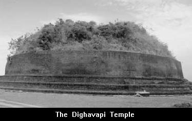
Dighavapi is an area which grew out of the ancient concept of the tank, the village and the temples its name implies. Lying in the Digamadulla area, the word 'Diga' was derived thus. Deegavapi was the tank which lent itself to this hamlet. And thus Dighavapi was born.
Located in the Ampara district, Dighavapi is believed to be one of the 'Solosmasthana' or the sixteen places visited by the Buddha on three occasions when he came to Sri Lanka. It is said to be the last place where the Buddha was seated. The stupa ruins were discovered in 1810.
The controversy surrounding the Dighavapi is over the land outside the temple grounds. The legally demarcated area belonging to the temple measures 585 acres. Outside the temple boundary lies more than 12,000 acres of land in which it is believed are ruins and artefacts of many ancient buddhist places of worship. And many Buddhist groups say that this vast land area historically belonged to the Dighavapi temple.
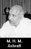
Minister and Sri Lanka Muslim Congress leader M.H.M. Ashraff, who represents Digamadulla area, however claims that the estimated land extent was 3,000 acres, not 12,000.
King Saddhatissa is said to have built the Dighavapi Chaitya in the
2nd Century B.C. Although the king had donated thousands of acres, today
there is documentary evidence only for 585 acres, as the 'sel lipi' (stone
inscription) presented by King Saddhatissa has been lost or stolen. 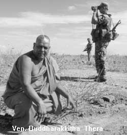
In early days, the extent of land had been measured in informal ways. For instance, all the lands in sight when viewed from the pinnacle of a chaitya.
Another method used was the 'thammattama'. Under this method, a drum was played and the farthest distance that the sound could be heard was demarcated.
For years the outlying lands around Dighavapi temple were untouched till Mr. Ashraff together with the chief priest of the Dighavapi temple, Ven. Nannapurave Buddharakhitha Nayake Thera, started road construction work within the area.
In 1997, a track which existed during the time of the former chief incumbent of the Dighavapi Vihare, Ven. Revatha Nayake Thera, was improved when the present chief incumbent requested Minister Ashraff to construct a road.
The road which runs across Dighavapi temple lands, created much debate. The questions who was responsible for it, where was it leading were foremost in the minds of those caught in the controversy.
The Road Development Authority carried out the construction work of the 5 kilometre road upon the request of Minister Ashraff and Ven. Buddharakkitha Thera.
The allegation against Minister Ashraff was that he was proposing to resettle Muslims within this area.
Speaking to the people, The Sunday Times learnt that the issue of Dighavapi meant little or nothing to them. But many blamed the chief priest for the present crisis.
The people welcomed development, and felt that Minister Ashraff was the first politician in recent times to have taken an interest in developing the Dighavapi village.
"Ashraff is not responsible for giving out land. It is the priests who are selling land to the Muslims. Now these are Muslim areas," K.P. Podimahattaya said.
We also saw Sinhala-Muslim harmony and peaceful co-existence in the village with the Sinhalese providing their Muslim neighbours with livelihoods and support.
The people pointed their finger at the local authorities, blaming them for posing obstacles in the way of development. They accused the priests, grama sevakas and politicians of not taking interest in improving life in the village.
Some of the villagers expressed disgust at the state of affairs. They charged that the priest took little interest on the village affairs. Therefore the people were building another temple at Veheragala. Podimahattaya, a villager was virulent in his criticism of the temple. "The air over it stinks," he said meaning many things. "Rearing of cattle, goats and hens and selling of meat is what is being done for a living in this Buddhist village," he said. On the question of bulldozing which took place in 1997, villagers alleged they informed the priest about it but he took no steps to stop it. They said the priest had convinced them that road construction was going on.
Then the villagers wrote to the Buddha Sasana Ministry and the Nayake Theras of the Malwatte and Asgiriya chapters, requesting them to probe the incident.
Archaeology Department officials said they sought the help of the priest to identify a mound that surfaced when the land was bulldozed. But the the priest had insisted it was only a mound of soil, though stones of what is now believed to be an ancient chaitya were visible.
The Nagara letters on the bricks found around the bulldozed chaitya show that they belong to a very early date.
Todate, some 38 archaeological sites were identified and some people have been taken into custody over a second bulldozering incident, the Archaeology Department officials in Ampara said.
There were also allegations that stone pillars unearthed in the dozered area had gone missing.
According to the Buddha Sasana Ministry, the bulldozering carried out in the first instance was a mistake or through ignorance.
But many Buddhist groups and monks, including the popular Buddhist monk, Ven. Gangodawila Soma Thera, says Minister Ashraff should take responsibility for what they see as devastation around the Dighavapi area.
However, Ven. Buddh-arakkitha Thera defended Mr. Ashraff, saying it was upon his request that the SLMC leader began road construction.
He said three kilometres of road had been constructed during the days of Revatha Nayake Thera but after his death in 1950, the Oluvil people diverted the road towards Mankulam.
It was only after the completion of this road that people started coming to Dighavapi, from Oluvil and Akkraipattu, he said. The road which is from Oluvil to Mankulam lies on the border of the temple land. The new road is an 80 foot carpeted one from the Oluvil port, he said adding before the new road was built people had to trek a 30 miles long route from Oluvil to come to Dighavapi. According to Ven. Buddharakkitha Thera, the dozering was done by private contractors who stopped work when police intervened. But later they resumed the construction work with the permission of the Archaeology Department.
The Ven. Buddharakkitha Thera said the Archaeology Department had told
the contractors that there were no archaeological objects in that area.
But if they found any to hand them over to it. But when the contractors
were moving a machine over a mound, they damaged the chaitya underneath
and they stopped work, Ven. Buddharakhitha said. 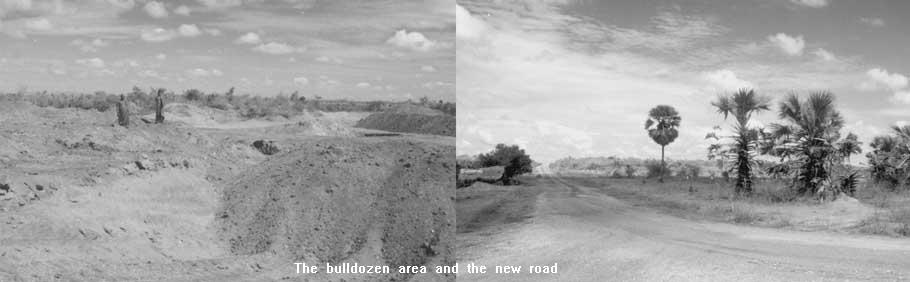
This prompted the Archaeology Department to act on the finding and begin excavation work, he said.
Ven. Buddharakkitha Thera denied any land distribution taking place at Dighavapi area, saying it was in place of Ponnanveli that lands were being distributed outside Dighavapi.
Ashraff: the temple has more land than what belongs to it
 The
following article is based on an interview with Minister and Sri Lanka
Muslim Congress leader M.H.M. Ashraff. He dismissed arguments that the
Dighavapi Vihare laid claims to 12,000 acres of land and denied allegations
regarding resettlement of Muslims within this land.
The
following article is based on an interview with Minister and Sri Lanka
Muslim Congress leader M.H.M. Ashraff. He dismissed arguments that the
Dighavapi Vihare laid claims to 12,000 acres of land and denied allegations
regarding resettlement of Muslims within this land.
Nowhere is it stated that 12,000 acres belong to Dighavapi. There is only one historical document called 'Sel Lipi', that talks of the extent of land.
It is described as 'bitthara vee amunu' - around three gunny bags of seed paddy. When you take a certain amount of seed paddy and throw, the extent covered belongs to the temple.
According to state surveyors, it covers about three thousand acres.
Where is the proof to claim that 12,000 acres belonged to temple?
Disappearance of sel lipi is an imagination. If you want to assert something, you can't come suddenly and talk about matters without anything in your hand. If you are really interested in finding the truth go by whatever is existing, don't imagine things.
What is there now is only one sel lipi given by King Rajasinghe. This sel lipi talks about a land in extent of 3,000 acres. The question arises only if that 3,000 acres is missing today. But today there are more than 5000-6000 acres in Digavapi. More than the extent of land referred to in the sel lipi.
Out of the 3000 acres, 585 acres were declared a sacred area during the UNP regime. Although this was declared sacred area, no one has seen the boundaries of the 585 acres. Except the little area around the temple the rest is jungle.
And there is no resettlement at all within the temple premises. Ponnanveli Kandam, where 120 Muslim farmers were cultivating for about 30-35 years was caught up within the sacred area. In 1983 when the sacred area was demarcated, these Muslim farmers who were cultivating on permits were asked to leave. Authorities refused to renew the permits on the grounds that Muslims cannot do cultivation in the sacred area.
The Government took over this land and handed it over to Sinhala farmers. And they were given permits for these lands.
From 1983 this bacame a political issue - you want this land, you don't want the Muslims to cultivate it because it's a sacred land, so give them an alternate land. Up to now they have not been given new land for cultivation.
During the Presidential election in 1994, this was one of the issues. Then, we gave the promise to resolve this problem by promising them alternate lands.
So all I did was I brought this matter to the notice of the Land Commissioner. The Land Commissioner decided to give them alternate land at Pallekadu, south of Oluvil. Dighavapi has nothing to do with Pallekadu.
Then the Survey Department did the blocking out and identified the land. Then the whole thing was a jungle area, and you have to start from somewhere, so a bulldozer started clearing.
While the bulldozer was clearing suddenly the Buddhist priest upon hearing the noise of it alerted us, saying it was Dighavapi land, we immediately stopped work.
When I asked where the boundary was, the priest couldn't tell because the whole area was jungle. I said this is a sensitive issue so we have to solve this problem.
Thus we suspended giving alternate lands to these people. I told them to take the Survey Plan and find out the boundaries to protect the three thousand acres, especially the 585 acres.
Then the Dighavapi Nayaka Thera said this would pose a problem and suggested a road on the southern boundary of the Dighavapi temple be constructed, connecting Dighavapi to Oluvil'.
There was no track road, there was nothing until we constructed the road. Not only did we construct a road, we also put 800 concrete milestones right round the 585 acres, so that in the future no one is going to dispute this. As the Sinhala people had requested to set up a Dighavapi model village, six hundred Sinhala families were resettled within the 3,000 acres.
All that I am trying to do is to give alternate lands to the people displaced at Ponnanveli Kandam.
Ven. Soma: Who is hiding Saddhatissa's sel lipi?
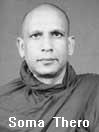 The
following article is written based on an interview with Ven. Gangodawila
Soma Thera who is spearheading a campaign to protect the Dighavapi.
The
following article is written based on an interview with Ven. Gangodawila
Soma Thera who is spearheading a campaign to protect the Dighavapi.
In Sri Lanka efforts are made to erase traces of a past while in other countries every effort is made to protect sites of archaeological value.
In today's world where world organsiations such as UNESCO are working round the clock to protect the world heritage sites, it is indeed a tragedy that those in office do not feel it sufficiently important to preserve the country's history.
It was the British Government which demarcated the 585 acre boundary setting apart the sacred lands. Though they occupied the country, they did not have a right to distribute lands.
According to a chief priest of the Dighavapi Vihare, the total land extent is 12,785 acres. But there is no documentary evidence to support this. There is only one 'sel lipi' (stone inscription) remaining a 'sel lipi' done by King Rajasinghe. But this has not much significance without a sel lipi presented by King Saddhatissa.
It is essential to find this 'sel lipi', which contains details of the land area belonging to the Dighavapi Vihare. King Saddhatissa also built a large number of chaityas in the area.
There is no reason for that 'sel lipi' to be lost. It had been there upto the year 1920. If it has been hidden that is a grave crime. If that 'sel lipi' is found, we will be able to prove the exact number of acres belonging to the temple because these two stone inscriptions have always been together. In those days they did not offer land to the temple in acre measures. It was from one hill to the next that people would donate lands.
I agree that nothing has been done within the 585 acres. It is beyond this that the encroachers have come in. In various parts of this land there are archaeological sites.
Although ruins and artefacts of many small chaityas are to be found beneath the ground, it is difficult to locate them as they lie far apart from one another and thus all of them will not be found easily. The 'avasa geval', houses occupied by the monks and 'dhana shala' were all located close to the chaitya.
However it has been revealed that Dighavapi chaitya had three parivara chaityas (smaller versions of the main chaitya built at a certain distance around the main chaitya). Going by this tradition, we should try to calculate the extent of land belonging to the Dighavpai vihare.
Another problem lies behind the proposed road running across the temple. We cannot say who is responsible for this. It is veiled in mystery.
The explanation given for the road construction was that it was for the use of pilgrims to the temple. It is now evident that the road is not leading to the temple. If the road was constructed to gain access to the temple it should stop at the temple. But this is not the case. Then where is this road leading?
Even in India, a country in which Hinduism is the majority religion, Buddhist places of worship are protected. They take an interest in locating and identifying these places of archaeological significance. It is a shame that Sri Lanka being a Buddhist country a similar interest is not in evidence.
On the question of resettlement of Muslim people, a process that began in 1997, was halted. Muslims must be given lands, but not right next to the temple.


Reflections
Editorial/ Opinion Contents
![]()
Front Page| News/Comment| Plus| Business| Sports| Sports Plus| Mirror Magazine
![]()
![]()
Please send your comments and suggestions on this web site to