Arts
Atop Pussellawa’s Garden of Eden
After a memorable camping experience in the hill country, my friends Minol, Suran and I were up for another adventure. We picked the weekend before the April New Year- our location this time the mountains of Pussellawa.
Chariots Path, an open plain on the mountain range behind Frotoft Estate in Pussellawa is said to be the path on which King Ravana took Sita Devi in his chariot to show her the beauty of his kingdom.
To reach here one must get off at Pussellawa town and take the Pussellawa – Perattasi bus which goes two km up through Delta Estate and Helboda Estate to Frotoft Estate. Getting off near the old Frotoft hospital, it is about one km up the tea estate to the trail head and then a two km hike up the mountains.
We met Suran at the Pettah CTB bus stand on Friday night. The Welimada bus left at 1.55 a.m. and we slept on and off till the conductor called out the Pussellawa stop.
It was 5.35 a.m. and the town was slowly waking up, with a few shops open here and there. A trishaw driver said we should take the Perattasi bus which starts from the town and head up the estate and from there the villagers would direct us.
The first bus was leaving around 8.30 a.m. and so we roamed about the town and spotting a temple, decided to wait there. Climbing a few steps just before the main entrance we sat down in a corner and had our breakfast. A monk came out and took us inside to the Bana Maduwa and said we could rest here.
The bus left Pussellawa at 8.15 a.m. Heading towards Nuwara Eliya it turned left on the road leading to up through the Delta estate, winding its way slowly up the beautiful tea estates. At certain bends the entire Kottmale valley could be seen.

Awesome sight: Sunrise from the mountain top
After about one hour and 20 minutes, at 9.40 a.m. we got off. One of the passengers we spoke to had called a tea plucker and asked him to show us the way to the trail head.
The almost one km journey from the bus stop to the trail head was just as beautiful as the bus ride; stunning views of green and blue. Our guide told us that a few months back some Chinese tourists had done the hike and Indians too visit the place, but not as often as earlier.
After a 40-minute walk through the estate we reached the trail head by 10.20 a.m. The trail starts on the border of the estate where the forest begins and our guide pointed towards a somewhat visible path. He told us to head straight down the path and after about 100 m, take the left path that would lead up to the plains.
The beginning of the trail was covered with thick undergrowth; the path was visible but hard to pass through. Coming near a big boulder we saw what looked like a path onto the left but decided to walk few metres ahead and see if any other path turned up.
To our relief, we came to a noticeable junction with a clear path to the left. From this point onwards the vegetation started to change with more trees and big bushes over six feet tall.
Now the weather was changing with dark clouds beginning to appear and the cold setting in. Suddenly we came to a point where the path seemed to diverge. This was tricky as we could not afford to get the path wrong with the rain closing in.
Then Suran came up with a brilliant idea – he suggested that one of us stay at the junction and the other two scout up 100 steps and come back to see which one was the most probable route. I stayed and five minutes later they were back with Suran saying his path continued to ascend, seeming the most likely.
Now the climb became steeper and we knew the summit should be close. After reaching a considerable altitude we came upon more flat ground with montane forest. But there was no sight of the plains.
We kept on going. Suddenly the path became covered with thick vegetation and passing through this dark tunnel-like place; there it was: Glory before our eyes! Out of the dark and into the light, we finally made it to the Chariots Path.

Chariots Path: The lonely splendour of the plains
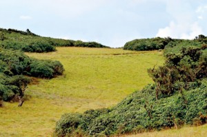
It was beyond words. Through all that thick forest this great open plains. The path once it climbs onto the top runs parallel to the plains and opens up at the end. The elevation at the plains was 1986 metres.
The time was 12.30 p.m. Elated, we dumped our bags and ran to the centre. We pulled out the Lion flag and our College (St. Joseph’s) flag and planted them.
The environment around was quite strange, the grass on the plains was not one flat patch but tiny patches of grass which made it really hard to walk on and in some places the gaps were so deep as if drains were cut in.
But a clear foot path could be traced. Luckily we encountered no leeches. The plain is surrounded with a certain thick bush about 4-5 feet at height with a few montane forest trees.
Selecting a location on the western corner just before a cliff we started pitching the tent. Now the weather had turned quite cold with mist closing in. Just as we had fixed the tent it began to drizzle.
This was the fun part, running about in the drizzle with ropes and sticks to fix the covers. In the mean time we managed to collect some firewood as well. Just as we had finished setting the last rain cover, the rain set in and we all jumped inside.
It was a heavy shower with strong wind but luckily the rain covers held. Tired out, we had our lunch of fried beef and bread and then fell asleep.
Around 4 p.m. I went to fill the bottles from a stream I had found earlier which was about 30m from the camp site. It was now full of water but yet so tiny that I had to use the smallest bottle to fill the others.
The others had managed to start a fire but maintaining it needed lot of work. We boiled water to make our signature drink, Marmite! During this time the weather was running wild, from clear skies to thick mist.
After the drink we walked around and sitting on a rock just near the cliff we enjoyed the beautiful scenery; endless mountains of the Central and Sabaragamuwa ranges.
By late evening it was freezing cold. We could hear many tiny creatures in the bushes but saw no animals except for a tiny bronzed frog (Hylarana temporalis). For dinner we had fried beef and bread again and went to sleep by 8 p.m.
With the greatest difficulty we woke up at 5 a.m. and rushed outside to get the fire going, warm up and check out the sunrise. To our amazement we could see lights on a faraway mountain top. This was Adam’s Peak with the Nallathaniya trail lit up.
As we walked to the eastern side to catch the sunrise we came upon another campsite where careless people had left broken bottles, biscuit wrappers etc. What a sad sight to see.
The sun rise was simply amazing. By now the time was around 6.30 a.m, and we walked around and filled our water bottles. It was sad to leave this place but we needed to go down early.
We had our breakfast, yet again beef and bread and we tried drying our shoes which were soaking wet by the fire.
At 7.30 a.m. we broke camp, got ready and leaving nothing behind but memories we said goodbye to Pussellawa’s Garden of Eden and began the climb down. I turned on the GPS and kept monitoring our position in case we missed the track.
The climb down was so quick that we made it to the trail head in less than an hour. At the tea estate we changed into shorts and slippers and headed down the road.
Along the way we met some friendly villagers and we also called our guide and informed him that we had safely come down.
This adventure yet again showed us the beauty of nature and our people. Camping out in the wild will always be the best times of our lives.

