|
|
||||||||
|
Good ole’ Grandpass The historical development of Grandpass, from
a ferry service to
The city of Colombo grew over the alluvial fan of the river Kelani. The river contributed immensely to its defence, and to maintain the ecological balance in the city’s environment. It provided water to Beira Lake through the St. Sebastian canal, and drained spill water to the sea via outlets in Galle Face and in a place near St. John’s fish market.
On the northern and north-eastern sides, it was a protective barrier to the city. The military expeditions led by the Portuguese, the Dutch and the British started from the direction of Negombo and crossed over the Kelani, either through the ferry at Wattala, or at Grandpass to attack Colombo. The people from Kandy and Negombo, including Kandyan envoys arrived in the city via the Grandpass ferry, and as a result, over the ages, particularly the vicinity of Grandpass became densely populated with a market place and a toll. Perhaps the Kelani was the most ferried river in the island in the 17th and 18th centuries. If we start from the estuary and head upstream, there was one ferry between the present Sri Wikrama Mawatha in Mattakkuliya and Hendala, referred to in the old documents as ‘Pas Betel’ and in modern maps as ‘Pasbetal’. The next one was between Nagalagam or present Grandpass and Peliyagoda. Further up there was one in Kelanimulla to cross over to Kelaniya Temple, which is now being replaced by a modern bridge. There was one in Kaduwela and another in Hangwella both replaced by new bridges.
Out of these, the two ferries close to Colombo were called ‘passo’ by the Portuguese and ‘pass’ by the British. When Victoria and the New Kelani bridges were opened to the public, the fame of Nagalagam and Pasbetal gradually declined. Subsequently, one more added in the Dutch times was referred to as Kleine Pas or ‘Small Pass’. This third one was not a ferry, but a sluice in St. Sebastian canal, which took water from the Kelani river to Beira Lake. ‘Pas Betel’ is located at the northernmost point of Colombo, which could be approached by the Mattakuliya Church Road and Sri Wikrama Mawatha. This nomenclature carries romance in plenty. When the Dutch took over Colombo from the Portuguese, they entered the outskirts of the city at this point, having already captured Negombo. The British did precisely the same, and placed a contingent of Wurtenburgs, a mercenary regiment under the command of Captain La Grevise, a Frenchman who unfortunately put his ‘jingals’ into the river and beat a hasty retreat. The etymology of the word ‘Pas Betel’ is explained in many ways. It is associated with the village name Wattala, therefore its correct name should be ‘Pas Wattala’ or ‘Wattala Pass’. Apparently, the Europeans mispronounced it and called it ‘Pas Betel’. The ferry at Wattala was ‘Pas Betel’ for the Portuguese, and later on account of the inability to pronounce it, it became ‘Pas Betel’, and this has also gone into documents. The Dutch continued the same as ‘Pas Betael’ and the British as ‘Pasbetal’. It is interesting to note that 12 selected fishermen called baddatoereas, who resided in and around ‘Pas Betael’ were obliged to provide fish, exclusively to the Governor’s House for his midday meal. The fish was to be delivered at a given time only to the steward of the Governor’s House in Colombo. These fishermen were allowed to cast their small nets only in the river between Mutwal and Pas Nakalagam. The order in this respect was issued in Colombo on October 5, 1706. The largest out of these passes is Grandpass, which in ancient times was called Nagalagam Tota; perhaps this must be the older name connected with worship of divine nagas. This place is within the ancient Kalaniya kingdom, where the conflict between two naga kings Culodara and Mahodara took place. The nagas are considered to be associated with water in classical literary traditions, and there would have been a guard stone or a similar object venerated by the laymen crossing the ferry.
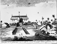
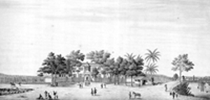
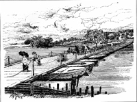
The Portuguese called this place Nacolagam, in order to differentiate the ferry of Wattala. They also called it Grande Passo, which became Grandpass later in the British times, which is still in common use. Grandpass is recorded by the Dutch in different ways, such as Groote Pas, Pas Nacollegam, Pas van Goensdorp, ‘Border guard of the Four Gravets of Colombo’, but never ‘Grandpass’. According to instructions issued to the caretaker of the Pas Nakelegame on July 9, 1670, this was an important gateway to Colombo, where the produce from Arandara, Ruvanwella and areas of the interior were brought to the city. It is recorded that he was instructed to oversee whether the locals passing the ferry carry arms and ammunition with them up and down, and if so, to issue them a licence after listing them. The transport of iron, gunpowder, bullets and saltpetre into the city was prohibited. Cash fines were imposed on undeclared goods. The arrack transported to the city was taxed at this point. Except for the supplies to the company, all other timber was similarly dealt with. The crafts passing Pas Nakelegame were checked, and a toll was charged. This arrangement indicates that Grandpass functioned as an important income-generating checkpoint to the Dutch company. This neighbourhood appears to have taken the fancy of the Dutch governors from early times. Governor Rijckloff van Goens (1664-75) was so enamoured of the spot that he laid out a large tract of ground along the river, which carried the name of Van Goensdorp or ‘Van Goens Village’ in many Dutch records. Van Goens, both father and son, were Dutch Governors in Colombo, who made Grand pass their country seat. Undoubtedly, this tradition must have been continued by his successors, and in 1777 Governor Iman Willem Falck (1765-85) had a villa in Grandpass with cinnamon planted in the garden. The last Dutch Governor Johan van Angelbeek (1794-96) was also said to have had a country house at Grandpass. “It contained a row of offices and a handsome farm-yard. There were two houses of one floor each for the accommodation of the family. These lie parallel to one another, and it is necessary to pass through the first to get at the second, which is raised on the embankment of the river. The stream is green, gliding along from the windows, and is broad, deep and rapid… General Macdowell and his staff lived there several months at a time.” An engraving of the Governor’s house in Grandpass is to be seen in Valentijn’s Oud and Nieuw Oost Ondien… published in 1726, which was translated into English by Prof. S. Arasaratnam and published by the Hakluyt Society, London in 1978. This was situated immediately to the north-east of the present Madampitiya Road, and the ferry at Grandpass on the road in the direction of Negombo. Valentijn seems to have taken his view from the end of Nagalagam Street. Grandpass came to be constantly crowded in the early British times with large flat bottom boats, which came down from Negombo with dried fish, roes and shrimps, firewood and other day-to-day supplies. These activities made the environment pleasant, and as a result a popular country seat was forming with large colonial mansions commanding wider prospects and a greater diversity of scenery, before the gentry diverted to Cinnamon Gardens in the early 20th century. A little to the east of the ferry, which connected Nagalagam Street with Peliyagoda, stood a bridge of boats. The bridge consisted of a number of boats placed next to each other in parallel formation, and held together by a number of planks fastened across. There were protecting rails on either side, and the bridge was lit with coconut oil street lamps at night. This kind of construction had the advantage of rising and falling with the tide and flood, and at certain times could have been hastily dismantled in the event of an invasion by the Kandyan troops or when water levels increased during the monsoon rains. After the ferry at Wattala, the bridge of boats was the most important crossing in the Kelani river to get into the outer environs of Colombo, and for that reason, the area gained the name ‘Great Pass’, now rendered Grandpass that would confound the historian studying place names. Robert Percival (1803) marked Grandpass in his map ‘Pas Betel’, and the reference to Petit Pas probably by mistake. It is Charles Francois de la Tombe in his travel account (1811), who called it in his own language, Petit Pas. During the period that ‘Small Pass’ received its name, the Beira Lake reached almost up to the foot of the Dam Street hill. The short stretch of ground between the two was a swamp, which the Dutch dammed and ‘polderised’ later. It was due to this reason that the dammed area came to be known as Dam Street, which is used even today. At the top of the pass was the stronghold of General Gerard Hulft (1656). The intrepid Dutch General had his camp and his council of war before the final assault on the Portuguese at the Fort of Colombo. The street crossing the ‘Hulft’s village’ today on the name board indicates ‘Hultsdorp’. However, its correct spelling should be ‘Hulftsdorp’. The law courts complex is situated in this locality. The ‘Small Pass’ has been built upon long since, and the geography of the place has changed beyond recognition. One of the earliest buildings in this vicinity in the British times was Colombo Kachcheri that still exists with extensive modifications. This building was constructed on a ground belonging to one of the earliest Government Agents of Colombo, Cadell. The position of the Government Agent was then called ‘Collector’. Based on this story the locality came to be known as Cadell Disage Watta or the garden belonging to Dissave Cadell. Over the ages this usage took a different direction, and is now called Kehel Watta after shortening the sound pattern to suit the Sinhala usage. From the commercial point of view, the most important Dutch canal in the city was the St. Sebastian canal. It was used to transport heavy goods from Grandpass to Beira Lake and then to the water front in the Colombo harbour. This route existed even in the 1920s, when the old Parliament building and the Secretariat were constructed; the heavy blocks of stone were brought from a quarry in Ruvanwella to the premises in Galle Face through this canal. Out of three famous passes in Colombo, only Grandpass now exists, limited only to its value as a place name. |
||||||||
Copyright © 2006 Wijeya Newspapers
Ltd. All rights reserved. |