News
Beaming in from space on ‘silent killer’ drought
Sri Lanka has been selected as the first regional country along with Cambodia to benefit from space technology in early predictions of drought – and political rivals India and China are co-operating with the United Nations to develop the mechanism.

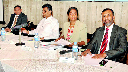
The Sri Lankan delegation at the inaugural session of the forum on Space Technology Applications for Drought Monitoring and Early Warning
News of the initiative came from a two-day forum on Space Technology Applications for Drought Monitoring and Early Warning this week with the participation of local and international scientists together with professionals in agriculture, water management and meteorology.
If drought warnings can be issued earlier, local authorities could take immediate action such as informing farmers to switch to more drought-resistant crops or implementing water management strategies.
But drought warnings usually come too late for farmers – after they have put their efforts in the ground, when seeds and plants are growing.
Ground-level data is currently used to predict droughts, but signs of drought can be observed from space long before they are visible to the human eye, and advances in space technology allow monitoring of indicators such as the condition of crops or the availability of water by analysing satellite images through special computer applications.
The United Nations Economic and Social Commission for Asia and the Pacific (ESCAP) together with the Arthur C. Clarke Centre Institute for Modern Technologies (ACCIMT) organised the forum this week to discuss how to use the space technology to predict  droughts in Sri Lankan conditions.
Addressing the forum, the Director of ESCAP’s Information and Communications Technology and Disaster Risk Reduction Division, Dr. Shamika Sirimanne reminded that drought is a ‘silent killer’ that does not get the attention that other natural disasters attract.
“Over the past three decades, it is estimated that droughts in the Asia-Pacific region have affected more than 1.3 billion people and caused damage of more than $US53 billion,” she revealed.
Advanced satellite technologies have been used by developed countries but local regions, highly dependent on agriculture and suffering from droughts as the severity of extreme climatic events worsened with climate change, lacked such assistance.
To bridge this gap, ESCAP launched its Regional Drought Mechanism Programme last year as a platform to provide timely and free satellite-based data, products and training to regional drought-prone countries with ultimate aim of transferring the technology to developing countries.
The region’s giants, China and India, with their own space programmes, have come forward to assist this effort to provide the pilot countries with satellite imagery, services, expert training and capacity development.
Dr. P.G. Diwakar of Indian Space Research Organisation said Indian scientists had already analysed some of the data collected for Sri Lankan droughts and his country was willing to give technological and other support for this venture. Dr. Diwakar said data extracted from three Indian satellites will to be helpful for this region.
A Sri Lankan team is already having training sessions with India and another team will fly to India at the end of this month for further training on how to use computer applications to issue early warnings based on satellite imagery.
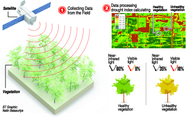
Arthur C. Clarke Institute research scientist Chandrima Subasinghe said initially vegetation change will be used as the indicator to monitor the onset of drought. The Normalised Difference Vegetation Index (NDVI) is used to monitor changes in the “greenness” of Earth as viewed from space.
NDVI is calculated from the visible and near-infrared light reflected by vegetation. Healthy vegetation absorbs most of the visible light that hits it and reflects a large portion of the near-infrared light. Unhealthy or sparse vegetation reflects more visible light and less near-infrared light, yielding a lower NDVI.
The implementing agencies should develop the best data indices in order to do make effective predictions, ACCIMT Director-General Sanath Panawennage said.
Addressing the inaugural session, Minister of Technology and Research, Patali Champika Ranawaka warned, “This year may witness the beginning of another El Niño period affecting Sri Lanka – possibly with serious implications for agriculture.
“We have great hope that ESCAP’s Regional Drought Mechanism will help Sri Lanka address this issue by expanding our options for monitoring and responding to agricultural drought, effectively harnessing the potential of space technology applications towards this end.”

