|
|
||||
|
A fortified maze Fort and Pettah, the hub of commercial life in Sri Lanka, have a colourful history spiced by our colonial heritage
Colombo owes its present day importance almost entirely to the influence of the European colonial administrations. Before the Portuguese established themselves in 1518, locals called it Kolom Tota or Kolamba. The earliest reference to the word Kolamba comes across in the thirteenth century classic Sidat Sangarava, where it says Kolamba karalu ä nipan sada piyevi nam, mean ‘Kolamba, karalu etcetera are known as native sounds’. James de Alwis confirms that Kolamba is a native term that means ‘landing place of vessels’ in his The Leisure Hours (1863).
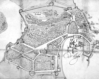
The Chinese traveller Wang Ta Yuan in about mid 14th century called the place ‘Kao-lang-pu’, which is far from complimentary either to the people or the place. Ibn Batuta, a contemporary Arab traveller, relates that ‘Kalempu was one of the finest and largest cities of Serendib’, which is the Arab name for Sri Lanka. Joao Ribeiro, the famous Portuguese writer, stated “…from being a small stockade of wood, Colombo came to be a fine city fortified with twelve bastions”. Constantine de Sa describes, “The city of Colombo is situated in the south side of a bay. The harbour is suitable during the summer for ships of all draughts, because of its good depth, but during the winter it is somewhat exposed to the winds, so that none but small ‘patachos’ (boats) can winter there. It has for its protection two bulwarks at the place …that of St. Laurenso has nine and the four pieces of artillery. The city consists of 500 households, which include 400 Portuguese casados (married men). The city is surrounded on the south side by a lake… for supporting the weak wall of the city, which is of low elevation and roofed with tiles. It has four bastions which are badly constructed… on the bastions are distributed eight pieces of artillery”. The Dutch cartographers thought the word ‘Colombo’ was derived from Sinhala ‘kola+amba’, which means mango tree bearing only foliage. As an alternative a dove was added to the mango tree and a coat-of-arms for Colombo prepared. The dove is white and nesting amidst the dark green leaves of the mango tree. When the Dutch town planner Adriaan de Leeuw (1659) designed a ground plan for Colombo on the orders of the Governor Rijckloff van Goens, he suggested having an elephant on the coat-of-arms of Colombo. The Portuguese maps of Colombo Fort show pictorial representations of the layout, but they are not drawn according to scale. On the same two dimensional plans the building façades indicated slanting on the flat ground. The Portuguese Colombo was a single unit consisting of both Fort and Pettah. The fortifications of Colombo constructed by the Portuguese had 12 small and large bastions, the biggest being St. Crous. There were a good number of churches, among them St. Francis, St. Augustine, St. Domingo and St. Laurens, together with Misericodia, that have been frequently highlighted in the maps. The Dutch captured the fortifications of Colombo after a continuous siege of seven months, which ended on May 12, 1656. The victory of the Dutch followed a massive reconstruction programme separating the city into two parts, Fort and Pettah. The fortress was called Casteel (castle), the Company town, where the high ranking officials and garrisons lived. The Oude Stad or Pettah was meant for free burghers, merchants and Asian people. On March 13, 1684 the Dutch Governor proclaimed that the houses in the castle should not be sold to the natives. This regulation was valid for more than a century, consolidating the fact that the Fort was exclusively for the Dutch. The urban configuration suggested by Adriaan de Leeuw shows an organic pattern of growth of Colombo, although it is not drawn according to principles of town planning. The Dutch felt that it was more convenient to reduce the size and the shape to make the city more compact and fortified. Therefore, the division of Fort and Pettah was meaningful. Eight bastions were added along the walls with a water-filled moat on the landside with three bridges. The Main Street or the Koningstraat was a wide avenue running from bastion Amsterdam to bastion Millelburg, which is presently named Sir Baron Jayatilake Mawatha. Leew’s plan of Colombo indicates the dominance of European pragmatism over formal aesthetics. The Casteel or inner city separated from the old city by an open area called ‘Buffaloes’ plain’, afterwards occupied by the Chalmer’s granaries and now converted into a car park. According to W. A. Nelson, the diameter of the circular main town, excluding the ditch from north to south, is about 850 and east to west 750 yards. The entire circuit, he observes, is one-and-a-quarter mile. The Fort has two principal streets running north to south, the former Queen Street now Janadhipati Mawatha and York Street. From east to west are Church Street, Chatham Street and Baillie Street, present Mudalige Mawatha. Hospital Street and Canal Row are two other smaller streets that exist, with their names unchanged even today. Jan Brandes, a Lutheran Minister, arrived in Colombo by the ship Stravenisse from Jakarta on October 10, 1785 on his homeward bound journey with his son. He was a capable painter, and on the roadstead of Colombo he started drawing what he saw first in the harbour from a distance. He had not the slightest indication that Colombo would be handed over to the British in another ten years. He observed a half demolished Portuguese church that still remains there together with several government buildings. He saw the Governor’s House, present Janadhipathi Mandiraya, wide open to the seaside along the water front. This building later used as the Queen’s House in British times was first built in the 1670s in a very heavy classicist style with a large garden. Brandes depicts this as a one-storey building with a roof interspersed with projecting upright windows on the sloping roof. The real Governor’s House was a two storied mansion fully open toward the sea. The rampart at this place was very low, and it provided the Governor with a full view over the harbour of Colombo and the ships anchored there. The houses in the Fort, James Cordiner says, “in general, have only one floor. There are a few, however, of two stories, which are much esteemed, and command charming prospects. The plan, according to which the houses are laid out, is almost uniform over the island. The pavement of the veranda is ascended by a flight of six to twelve steps. A passage, which is sometimes large enough to form a comfortable sitting-room, runs through the middle of the house. On each side of this is one apartment, and behind these a hall as long as the house, which may be from forty to one hundred feet. From the centre of this a portico or back veranda projects: and from each side of it, ranges of offices extend at right angles to the main building. These are terminated by a wall, and enclose an oblong court, which is paved with bricks, and contains a well of indifferent water. The two nearest rooms in the out-houses, that is, one on each side, are sometimes used as bed-chambers. The others afford a kitchen, cellars, pantries and stables. A back-door is generally attached to the end of the court, but many of the smaller houses are destitute of that convenience, and when the inhabitant of one of them keeps a horse, he enters at the same door with his master, passing through the vestibule and dining-room, on the way to his stable.” On February14, 1796 the British forces marched into Fort with no resistance and signed the Treaty of Capitulation. After about 40 years, in 1833, Colombo started to advance by leaps and bounds. At this time Fort was emerging as the principal place of business in Colombo. Europeans and military men were living there in cool and airy bungalows built by the Dutch with glass windows which appear to have been popular during the Dutch times. The street lines are the same as in the Dutch times, but their names were changed by the British, except Hospital Street. Canal Row, commemorating the old Dutch canal ran parallel to York Street. Facing Galle Face was the Galle Gate, which was the Grand Parade from the Governor’s House. Both sides of this street had equal lines of Suriya trees giving shade to the passers-by in the hot sun. (This contribution relates only to the Portuguese and the Dutch times. The British times will be dealt with later.) |
||||
Copyright © 2006 Wijeya Newspapers
Ltd. All rights reserved. |