
The India-Sri Lanka Navy Joint Hydrographic Survey completed its second phase this week which had commenced with the arrival of the Indian Naval Ship Sutlej on 26th October this year, Navy said.
The survey extended to a depth contour of 200 m from the coastline, ranging from Colombo to Galle. Data collected helped to identify the changes of morphology triggered by the Tsunami in 2004 and update information with regard to constructions including small harbours, break waters etc. that have come up along the coastline. The third phase of the survey is scheduled to be carried out from Great Basses to Sangamankanda next year.
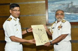
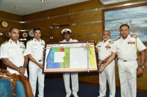
The fair sheet containing the soundings from the Hydrographic Survey was handed over to the Commander of the Navy, Vice Admiral Sirimevan Ranasinghe by the Commanding Officer INS Sutlej, Captain Tribhuvan Singh at the Naval Headquarters.
Chief Hydrography Officer of the Sri Lanka Navy, Rear Admiral Sisira Jayakody and the Indian Defence Attaché were also present during the occasion.


An Attorney at law and his wife was shot dead in the car park of a super market in Akuregoda today evening.


Read this week’s Sunday Times for your interesting articles


Leave Comments