Has the drone delivered my parcel yet?

Figure 1
During the curfew imposed as a result of COVID-19 a few months ago, some people strayed onto a street in Colombo. Suddenly, a Phantom Pro drone launched by the Air Force appeared in the sky and monitored their movements. The Police rushed in to arrest them before the miscreants could understand what was going on. So, policing such offenders is a function that can be performed by a drone, but there are many more.
What is a drone?
Drone technology has the potential of transforming the whole world into a new way of functioning and is based on a number of technologies. A drone needs to fly autonomously so it will need an inertial measurement sensor, global position sensor (GPS), airspeed sensor, barometer, servo motors, remote controller, mission planning software, flight controller, and a telemetry radio link.

Figure 2
The two main types of drones are winged and multi-rotor. Winged drones (conceptually similar to fixed wing airplanes) are energy-efficient and can fly long durations, but need a fairly large open space for taking off and landing. On the other hand, multi-rotor drones (similar to helicopters) do not need a large open area to operate but are energy-inefficient.The local drones such as CeyBee, CeyTwin, CeyMapper and CeyHawk are winged drones, whereas CeyHex is a multi-rotor drone.
Revolutionary two-in-one drone
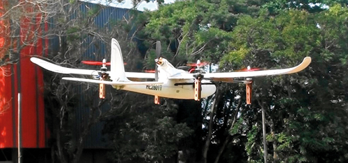
In a hybrid drone, a multi-rotor structure is used for taking off and landing while a winged structure is used for flying in the mission. The hybrid drone can therefore operate anywhere with a long endurance. In 2017, the research team led by Professor Rohan Munasinghe at the University of Moratuwa started experimenting with Hornet, a quadrotor-fixed wing hybrid drone (Figure 1), funded by the National Research Council (NRC) of Sri Lanka.
Hornet combines two separate control systems. The quadrotor mode is used for taking off and landing, operating in a very small area, while fixed-wing flying gives it high endurance. The quadrotor, a multi-rotor controller, operates during take-off until the drone climbs to a predefined altitude, and then the winged controller starts the pusher propeller, causing it to fly like a plane. As the drone gains lift from the wings due to forward speed, the multi-rotor controller can shut down the rotors until they come to a complete stop when the drone gains the required speed. This makes the Hornet very energy efficient.
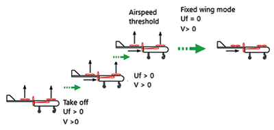
Energy efficiency is very important for drones as all energy has to be drawn from an onboard battery and its weight will reduce the payload. The latest innovation is to launch the drone in a ‘bird’ (i.e. inclined) takeoff mode using both quad and plane modes (Figure 2), thus reducing 25% of the energy required for purely vertical quad mode takeoff.
Applications of drones
Drones can be deployed for various applications now carried out on the ground. Since they are light-weight, fully autonomous, reliable, and capable of carrying out various types of missions, they are becoming popular in various fields because of their ability to do the job at a lower cost, in a shorter time, and with an acceptable accuracy and precision. The benefits of drones are many, and include the following four applications:
Aerial surveying:
When a drone is deployed for aerial surveying, it takes photos with 60%-80% overlap between adjacent images, so that every point on the ground is recorded in many photographs taken from various locations. Each photograph is tagged with the drone position, heading, and altitude at the time of shooting. Using specific image processing software, the tagged photographs can be stitched together by tracking the same features on adjacent photographs. The maps created this way are geo-referenced by including to it a few ground control points (GCP).
The drone startup company of the University of Moratuwa, Pristine Innovations (Pvt) Ltd, created the 6.5 square km high precision survey map of Bandaranaike International Airport, using the aerial photos taken by the CeyTwin. Similarly, it created the 86 square km survey map of Kantale Sugar Corporation premises, using the aerial photos taken by the CeyBee drone. Later on, it developed local drone technology for high precision aerial surveying.
Agriculture applications:
In agriculture applications, a drone carries a multi-spectral camera and takes photographs of the cultivated field in green, red, near infra-red, and infra-red. Just like in aerial surveying, these images are stitched together to create maps of different colour emission, enabling agronomically significant information to be extracted.
Natural disasters:
Natural disasters block access routes to affected areas due to floods, mud slides, and fallen trees. The most effective and perhaps only means of getting to victims in such situations is using drones. For example, the drone CeyMapper is 3.5 kg in weight and powered by an 8Ah battery to give it a 35-minute flight time. It takes off fully autonomously from a catapult, and lands using an auto-ejected parachute. Currently, the research team is further developing this drone, introducing a 10cc petrol engine so that its flight time can be extended to 90 minutes. This project was fully funded by the United Nations Development Programme (UNDP).
Small-package delivery:
Drones can be used for delivering small packages. Global leaders like Amazon, and local companies such as Kapruka and WoW.lk, are working on getting drones to make deliveries within a few minutes. This technology has been fully developed at the University of Moratuwa with the DeliAir drone, which includes a mobile App to place the order and select drone delivery times and options. Drones can lift a small package of 1 kg, fly to a nearby destination within 15 km in 10 minutes, deliver the package and fly back to the warehouse safely.
Local technology for local use?
Any local technology can only thrive on the basis of local use, and drones are no exception. If local drones are used for aerial mapping, at least 50% of the cost can be saved. Moreover, technical development locally will help the country to earn foreign exchange by selling or deploying drones outside the country.
Drones are low cost and affordable, with all technical support available locally. Local drone technology is ripe for exploitation by government institutions and local industries. Several government institutions such as the Survey Department, Ceylon Electricity Board and Water Board have already tested locally developed drones for their applications.
(This research was funded by the National Research Council under grant IDG 14-123, and awarded to Professor Rohan Munasinghe at the University of Moratuwa. Asitha Jayawardena was commissioned to write this article as part of the science publicity programme of the National Academy of Sciences of Sri Lanka).


