
|
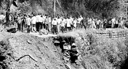
Sliding towards disaster About 2000 families would have to be relocated from landslide prone areas in the Nuwara Eliya district if their safety was to be ensured, Government Agent R.M.B. Ratnayake warned. He said about 1000 acres of land would be needed as many of the families depended on farming for their income. Meanwhile the Institute of Engineers of Sri Lanka (IESL) has raised the question whether proper implementation of counter measures could have minimized the effects of last week’s landslides that claimed 16 lives in Walapane and Hanguranketa.
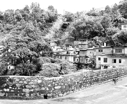
IESL vice president -Daya Mallawarachchi said the institute had been involved in successful implementation of projects concerning the prevention of landslides and more such remedial measures were needed urgently. He said about Rs 10 million should be allocated for mitigation and remedial measures. "The policy of abandoning landslide prone areas and relocating families is not a long term answer to the problem. We should take effective countermeasures to prevent these disasters from happening," he said. Nearly 14 months back, a comprehensive Disaster Management Act was approved in Parliament raising hope that precautinary measures would be given as much priority as disaster relief operations. But, in the case of the areas of Walapane and Hanguranketha in Nuwara Eliya little action appeared to have been taken to prevent landslides. Unplanned chena cultivation, release of land for tobacco plantation have been identified as some of the key reasons for the landslides by the Nuwara Eliya Government Agent’s office. But little action has been taken to control these cultivations resulting in widespread damage to about 4,000 acres of land in the district. Tobacco cultivation in the Walapane and Hanguranketha areas have resulted in the deforestation of many hilly parts, which scientists have identified as the main cause of the landslides.
The Disaster Management Act provides for a national plan to minimize damage from such disasters, yet for the Nuwara Eliya and Baudulla districts which are considered landslide and earthsilp prone areas plans are yet to be prepared. Meanwhile The Disaster Management Centre (DMC) set up under the Act is working towards relocating the families affected by the landslides. Although programmes have been drawn up under the Act they have been slow in implementation, The Sunday Times learns. and Ratnapura none of them had been implemented so far. Meanwhile The National Building Research Organization, (NBRO) has been holding discussions regarding the guidelines necessary for the construction of buildings in areas identified as landslide zones. The NBRO has categorized active landslide areas as medium or high hazard and recommended different guidelines for construction in these areas. R. Bandara, Head of Land Slide Studies and Services Division of the NBRO said they were also conducting awareness programs to educate planners and designers on construction in landslide prone slopes. He said that the NBRO has also recommended the relocation of people residing in high risk areas."We are a research organization and we do not possess the power to implement any of our guidelines. We can only recommend a course of action to the local authorities," he said. Mr. Bandara said that strict guidelines should be followed for construction in the medium hazard zones while high risk zones should be untouched. This however rarely takes place as it is not supported by the law. The activities of the institute have also been hampered by the lack of staff who are unable to cope with the sudden rash of landslides. The NBRO which started its operations in 1990 with 25 scientists now have only 13. Its team of scientists is finding it difficult to cover 8000 square kilometres of land that comes under its purview. However, other state institutions including the DMC the Irrigation Department, the Meteorological Department and the Road Development Authority (RDA) are also working towards the prevention of landslides.Elaborating on this Mr. Bandara said the RDA now consults the NBRO when constructing roads in the danger zones. However The Sunday Times learns that little monitoring is done before approval is given to build roads. It is also learnt that vegetable plantations in the hill country have also contributed to increasing the risks of landslides in the area. The water used in the cultivation of the land reportedly damages the soil beneath causing erosion. Many tea plantations in the Kandapola area have been converted into vegetable plots increasing this danger as the planting of vegetables requires farmers to dig deep into the soil resulting in erosion.Small water ponds are also built in the hilly areas for farming purposes which allows water to seep through into the soil creating access water which harms the soil. Scientists fear this would create more landslides during heavy showers.
|
|| Front
Page | News | Editorial | Columns | Sports | Plus | Financial
Times | International | Mirror | TV
Times | Funday
Times || |
| |
Copyright
2007 Wijeya
Newspapers Ltd.Colombo. Sri Lanka. |