Sunday Times 2
Will this be the first new cloud type in 60 years?
Since 1951 clouds have remained fairly easy to classify, with about 80 separate classifications officially recognised.

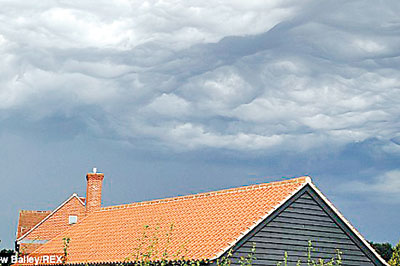
Ominous: A type of cloud first photographed in Iowa could soon be added to the International Cloud Atlas. Called undulatus asperatus it would be the first new cloud type since 1951. Gavin Pretor-Pinney of the Cloud Appreciation Society is campaigning for the new classification. It is pictured here above Bentley, Suffolk
But that could all be set to change next November if one enthusiast can seek official classification of a new cloud type.
Known as Undulatus asperatus, a group are now clamouring for the cloud shape to be included in the International Cloud Atlas.
The classification describes a wavy cloud that seems to protrude down from the sky, and is often a sign of a storm being on its way.
The first part, ‘undulatus’, translates as ‘wavy’ and is already used to classify certain types of cloud.
Asperatus, meanwhile is the past participle of aspero in Latin – which means ‘to roughen’. Thus, the name can be taken to mean ‘roughened wave’.
The first images of the cloud formation were taken in Iowa in 2005, before members of the CAS started to find more examples around the world.
Graham Anderson, an observation scientist at the UK Met Office who also did his Masters on Asparatus clouds, told MailOnline this cloud type was very, very rare.
This is one of the reasons it has not been classified yet, because evidence was needed from people taking pictures of the cloud type.
It forms when ‘wind moves a mammatus cloud,’ Mr Anderson said.
‘One theory is that when you model conditions for a mammatus cloud and then add wind, it gets features that look like Undulatus,’ he continues.
‘It forms near storms, and is most frequently observed near a mass of storms in the US, quite often in conjunction with very big thunderstorms.’

The name undulatus asperatus (seen here) translates as 'roughened wave' and is said to be a mammatus cloud that has been shaped by wind
But beyond that he says its formation is ‘not really known.’
To classify it, the Royal Meteorological Society required more evidence of the cloud type’s existence, which has been gathered over the last few years.
And now the cloud type has been recommended by a WMO task team for inclusion in the International Cloud Atlas, the latest edition of which is thought to be lined up for release next year.
In a bid to get it formally recognised, the CAS has been gathering many pictures of the formation and helping with academic research.
Since then the rather complex formation has been spotted in France, Norway, Salcome in Devon, Middlesbrough, Perthshire in Scotland and elsewhere
And in 2009 Mr Pretor-Pinney first proposed the new classification.
‘The formations were more dramatic and exaggerated than usual,’ he told the Guardian.
‘Undulatus like they were turned up to 11. I began to wonder what would happen if you think there is a case for a new classification.’
Now Mr Pretor-Pinney and the 37,000 or so members of the CAS face an anxious wait to see if their cloud type makes the International Cloud Atlas next November.
© Daily Mail, London

