Sunday Times 2
Climate change to be revealed in unprecedented detail
A groundbreaking satellite that changes the way we see the world has been launched.

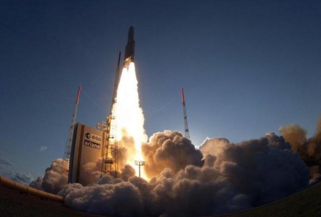
Sentinel-1A lifted off on a Soyuz launcher from Europe's Spaceport in French Guiana (AFP
Called Sentinel-1A, it launched from French Guiana at 21:02 GMT (15:02 EST) and soon after mission controllers confirmed they had made contact wiht the craft, to cheering in the control room.
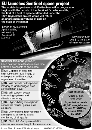
It will be the first of a pair of satellites to launch into space, with the second – called Sentinel-1B – due to launch in 2015.
The pair is the first of the new Esa Sentinel family of satellites that will map our planet like never before.
Sentinel 1-A launched on a Soyuz rocket from Europe’s Spaceport and will be placed into an Earth orbit between an altitude of 150 and 250 miles (250 and 400km).
Using radar imagery, it will then begin mapping the surface of Earth.
Countries across Europe have spent €7.5bn (£6.2bn; $10.3bn) on the project that will run until the end of the decade.
Its sensitivity will allow it to detect changes in the climate – particularly those caused by human interference.
This will complement Esa’s existing Copernicus Climate Change service, the goal of which is to respond to environmental and societal challenges associated with climate variability.
The Sentinel family of satellites will give scientists the data they need to determine the current state of our planet. It will also enable scientists to continue to fine-tune their predictions of Earth’s future.
 The overwhelming scientific consensus is that our climate will be damaged beyond repair if humanity does not stop harming the environment.
Sentinel-1A will be able to observe Earth both day and night, and in any weather conditions – a first for observation satellites.
This means that during disasters, including floods and earthquakes, the satellite could help provide support and relief for those on the ground.
‘Sentinel-1A is using radar waves to image Earth’s surface,’ Mission Scientist Malcolm Davidson told MailOnline.
‘It can penetrate through clouds and map Earth, so in the case of flooding this ability is important and it can generate maps of areas that are flooded. ‘It can recognise, quite accurately, the difference between water and non-water.’
Climate studies and disaster relief aren’t the only uses for the satellite.
Its exceptional level of accuracy means it can also provide information on miniscule details on Earth’s surface.
From its orbit it is able to detect changes on Earth down to just a few millimetres.
This means it couldtheoretically predict when a building will collapse, detect emerging sinkholes in the ground, or study volcanic activity.
It can also track the world’s shipping lanes, something that has not yet been done by any satellite in Earth orbit.
‘With hazards, such as sinkholes developing, we will be able to look where there will be structural damage over time,’ continued Davidson.
‘In extreme cases we could predict if a building could collapse or not.’
All of the Sentinel satellites are expected to be launched in the next few years, and together they will provide data that could be used for 20 to 30 years, according to Davidson.
Sentinel-1A is designed to last seven years but Davidson added that, like a fridge, ‘you have a guarantee but I think as a consumer you usually hope it lasts longer.’
© Daily Mail, London
|
ESA’S SENTINEL FAMILY Sentinel-1 is a polar-orbiting, all-weather, day-and-night radar imaging mission for land and ocean services. |


