We drive past the picturesque blue China Bay and cross the newest and longest bridge in Sri Lanka running over Trincomalee’s Kinniyai lagoon for a distance of 300 metres. Earlier the ferry transported people, goods and vehicles to and fro.
Our destination is Seruwila Mangala Viharaya. We proceed to Tamaravillu where we await the ferry, queuing up along with other vehicles. But the wait is tedious. It is a long week-end and the landing point is crowded. From there, another drive takes us to the embarkation point to the second ferry near Upparu. One drives again to arrive at the third ferry point at Mutur. All the three waterways to be crossed are tributaries of the Mahaweli River which fall into the Koddiar Bay and into the sea. From the embarkation point of the third ferry at Mutur, the distance to Seruwila is around 25 km.
The ferry experience is said to be a novel one. When the ferry comes to shore, the door is flung down and it becomes a ramp. The vehicles drive up to the vessel from the sandy banks. Three vehicles can be accommodated at a time, along with their drivers and a few bicycles squeezed in. The journey is only about 15 minutes one way since the ferry speed is quite slow as it chugs along. But if one decides to go by ferry, it is important to find out when the last ferry for the day will be for the return journey or you could be stranded in the middle of two ferry points by dusk. Deciding to skip the ferry, we made the long drive from Kinniyai to Seruwila.
Seruwila has always been a place of veneration for Buddhists. Also called Wilgam Vihara (not to be confused with Velgam Vihara, also in the Trincomalee district), the Seruwila Vihara was built by King Kavantissa (father of King Dutugemunu) of Ruhuna to enshrine the Forehead Relics of the Buddha (Lalata Dhatuwa).
It is believed that on the third visit of Gautama Buddha to Kelaniya, he also visited Seruwila. Thus it is one of the “Solosmasthana” ( the 16 places that Buddhists of this country are expected to visit and pay homage to), inclusive of the Atamasthana (eight places) which are in Anuradhapura. It dates back to the 2nd Century BC and is therefore around 2231 years old. It is on the eastern bank of the huge Allai tank.
Nominations have been sent to Paris from Sri Lanka to declare it as a UNESCO World Heritage site and a decision is still pending.
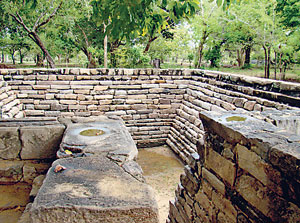 |
| Ruins at Seruwila |
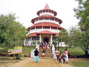 |
| The four-tiered pagoda built in 1982 |
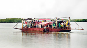 |
| A novel experience: On the ferry |
Overland, the best way to reach Seruwila Mangala Viharaya is to drive from Kantale along the main Habarana -Trincomalee road, a distance of around 48 km. Part of the way is along a gravel road in good condition unless it rains and gets muddy. One passes jungle and we saw many peacocks and even a huge wild elephant in the distance. We also crossed a broad bridge across the Mahaweli River which flowed by towards the sea.
With the Chola and Pandyan invasions and the breakdown of the Anuradhapura and Polonnaruwa civilizations, Seruwila went into ruin and was enveloped by jungle. It was resurrected by a young Thera from the South, Ven. Dombagasare Sumedankara in 1923 who faced many hazards to find the ruined temple in the thick jungle. He arrived by boat and trekked through the jungle for many miles to discover the ruins. Only Veddahs lived here and it was infested with snakes and wild animals.
Bhikku Sumedankara formed a society by making friends with the people of the area. He was able to persuade many wealthy Buddhists to give donations to resurrect the dagoba. For more than 60 years this Bhikku protected the temple till his death in 1984 at the age of 92 years. In 1982 a new shrine room (‘Buduge’) was built here, away from the dagoba in the shape of a four- tiered pagoda. Major reconstruction and restoration work got underway last year, funded by private donations as well as by the state.
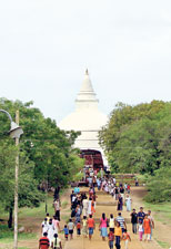
Busloads of Buddhist pilgrims flocked to Seruwila that week-end we visited it as it coincided with the “Katina Pinkama”.
We hurried back so as not to travel at dusk on the jungle route. Our drive back seemed easier as our trepidation over the unknown route had subsided. As we came to Kantale we passed by the massive reservoir built by King Aggabodhi II who reigned from 60-614 AD.
The catchment area of the tank is about 20,000 hectares. The tank receives irrigation water diverted from the Mahaweli River. It is stupendously big and awe-inspiring as you drive for many metres to pass it by. |