
Of moving plates and aftershocksAn insight on the recent tremors felt in Sri Lanka Recent reports in the local press indicated earth tremors in the Lunugam Vehera and Tissamaharama areas that caused damage to dwellings and were felt by the villagers. Investigations conducted by Geological Survey and Mines Bureau reported that these tremors were caused by undersea earthquakes. The Minister of Disaster Preparedness and Human Rights in a press conference stated that an undersea earthquake measuring 5.5 on the Richter scale was reported about 200 miles off the south coast and the tremors may have been related to aftershocks. Since the 2004 tsunami, such tremors have been felt frequently on land in Sri Lanka.
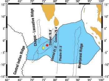
The cause of the tsunami has been attributed to a severe earthquake along the plate boundary of the Indian Plate and the Sunda Plate and the Burma Micro Plate. The earthquake of 9.3 released energy due to the subduction of the Indian Plate below the Burma Micro Plate along a 1200 km fault. The energy released was so devastating, the tsunami generated destroyed coastal regions of Sri Lanka causing widespread damage and loss of nearly 40,000 lives. This tsunami also affected most countries in the western Indian Ocean and was felt as far as Seychelles and Tanzania. Scientists have now predicted that such an undersea earthquake will not occur for the next 300 to 400 years along this section of the Plate margin. However, the aftermath of such tectonic movements in other areas of the Indian Ocean have to be closely monitored especially in the Central Indian Ocean. A fundamental principle of the plate tectonic theory is that the earth’s surface is divided into rigid plates that move together and apart like pieces of a jigsaw puzzle. Scientists have recognized 12 plates. However, recent research studies have indicated 13 plates and it has now been confirmed that the Indo Australian Plate long identified as a single plate on which both India and Australia lie appears to have broken apart south of the Equator beneath the Indian Ocean. Plate Tectonic Theory has postulated that for some 50 million years (Ma) the Indian subcontinent has been pushing northward into Eurasia forcefully raising the Tibetan Plateau and the Himalayan Mountains. The research suggests about 8 (Ma) ago the enormous stress built up resulted in the breaking up of the Indo-Australian Plate. Accordingly there are now two separate plates. The research carried out in the 1970s first discovered a broad zone, stretching more than 600 miles from east to west where the equatorial Indian Ocean floor compressed and deformed. Dr. Cochran, chief scientist from Lamont –Doherty Oceanographic Institute USA who analyzed drill core samples from the sea floor concluded that such deformation occurred about 8 (Ma) ago at the same time the Tibetan Plateau had reached its greatest height. Richard Gordon and Seth Stein at Northwestern University USA further analyzing the data theorized that the movements of the newly created seafloor could be explained only if a distinct plate boundary existed between separate Indian and Australian plates across the equatorial Indian Ocean. If this theory is correct the ocean floor in the eastern part of the new plate boundary should be compressed, buckled, cracked and eventually thrust upwards along the cracks. More importantly if a separate Australian Plate was rotating counterclockwise in relation to a separate Indian Plate the amount of compression should increase rapidly and systematically from west to east across the Central Indian Ocean. Further research has also indicated that the two separate Indian and Australian Plates are now converging and the compression of oceanic lithosphere in the Central Indian Ocean originally regarded as “intra plate” is a broad plate boundary between the Indian and Australian Plates that are moving independently. The map on the page indicates the location of seismic lines and undersea ridges in the central Indian Ocean. Special emphasis must be made to the position of Sri Lanka to the shaded area in the map showing the broad region of deformation. It is likely that the North South and East West compression of ocean floor in this region is due to sub sea earthquakes along minor fault lines. When such movements occur it gives rise to after shocks that are felt in Sri Lanka, the closest landmass. However, it is very unlikely that such earthquakes would generate a tsunami of any magnitude. Nevertheless it is strongly recommended that the earth tremors should be observed regularly by establishing seismic stations in the areas affected. Such stations should be tied up to the GSMB seismograph at Pallekelle. Such tremors on land if increased to a magnitude of over 5.5 or 6 on the Richter scale would cause damage to property and even loss of human lives. (The writer is a Professional Geologist with 40 years experience and former Director of Geological Survey Department, present GSMB) |
|| Front
Page | News | Editorial | Columns | Sports | Plus | Financial
Times | International | Mirror | TV
Times | Funday
Times || |
| |
Copyright
2007 Wijeya
Newspapers Ltd.Colombo. Sri Lanka. |